
3T5 Fayette Regional Air Center Airport
La Grange, TX · 2 miles W of LA GRANGE, TX
Public
Non-towered
Publicly-owned
Live ATC
Current weather
Forecast (TAF)
Weather
Unicom
Departure
Approach
Location & operations
- Elevation
- 324.0 ft
- Coordinates
- 29-54-28.7000N 096-57-00.0000W
- Lat / Long
- 29.9079722, -96.95
- Mag. variation
- 06E (2000)
- Time zone
- UTC -5 (UTC -6 during Standard Time)
- Activated
- 01/1992
- ARTCC
- HOUSTON CENTER
- FSS
- MONTGOMERY COUNTY FLIGHT SERVICE STATION
- NOTAMs facility
- 3T5 (NOTAM-D service available)
- Attendance
- MON-FRI 0900-1700 FOR ARPT ATTENDANT AFT HRS CALL 979-966-9139.
- Wind indicator
- lighted
- Segmented circle
- yes
- Beacon
- white-green (lighted land airport) Operates sunset to sunrise.
- Lights
- DUSK-DAWN. MIRL RWY 16/34 PRESET LOW INTST; TO INCR INTST ACTVT CTAF.
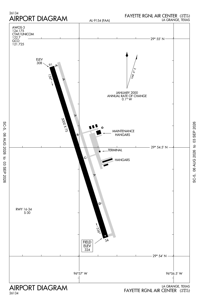
Airport diagram FAA official
Range from 3T5
Runways
Longest 5,000 ft
Tap a runway to see its details.
Waiting for current wind…
- Dimensions
- 5000 x 75 ft. / 1524 x 23 m
- Surface
- asphalt, in good condition
- Edge lights
- medium intensity
- Weight bearing
- Single wheel 30.0
Runway 16
- Heading
- 156 magnetic, 162 true
- VGSI / PAPI
- 2-light PAPI on left (3.00 degrees glide path)
- Markings
- nonprecision, in good condition
- Touchdown point
- yes, no lights
- REIL
- yes
- Traffic pattern
- left
- Threshold elevation
- 307.7 ft.
- Obstructions
- none
Runway 34
- Heading
- 336 magnetic, 342 true
- VGSI / PAPI
- 2-light PAPI on left (3.00 degrees glide path)
- Markings
- nonprecision, in good condition
- Touchdown point
- yes, no lights
- REIL
- yes
- Traffic pattern
- left
- Threshold elevation
- 324.0 ft.
- Obstructions
- 15 ft. trees, 475 ft. from runway, 110 ft. left of centerline, 18:1 slope to clear
Terminal procedures FAA d-TPP · cycle 2608 · through 0901Z 09/03/26
Departures — DP / ODP 2
Approaches — IAP 2
Arrivals — STAR 0
None published.
Procedure charts published by the FAA (public domain). Confirm the current cycle before flight.
Communications
- Control Tower
- No
Services
- Fuel
- Fuel available
- 100LL JET-A
- Parking
- tiedowns
- Airframe service
- NONE
- Powerplant service
- NONE
Airport data aggregated from public FAA/AirNav sources for reference only — always consult official charts and NOTAMs for flight planning.
