
KHTW Lawrence County Airpark
· 2 miles WSW of central business district of the associated city
Public
Non-towered
Publicly-owned
ICAO KHTW
Live ATC
Current weather
Forecast (TAF)
Unicom
Location & operations
- Elevation
- 567.1 ft
- Coordinates
- 38-25-08.8000N 082-29-41.4000W
- Lat / Long
- 38.4191111, -82.4948333
- Mag. variation
- 05W (1985)
- Time zone
- UTC -4 (UTC -5 during Standard Time)
- Activated
- 10/1937
- ARTCC
- INDIANAPOLIS CENTER
- FSS
- DAYTON FLIGHT SERVICE STATION
- NOTAMs facility
- DAY (NOTAM-D service available)
- Attendance
- UNATNDD
- Pattern altitude
- 1607.1 ft. MSL
- Wind indicator
- lighted
- Segmented circle
- no
- Beacon
- white-green (lighted land airport) Operates sunset to sunrise.
- Lights
- ACTVT MIRL RWY 08/26 - CTAF.
Airport diagram
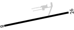
Range from KHTW
Runways
Longest 2,998 ft
Tap a runway to see its details.
Waiting for current wind…
- Dimensions
- 2998 x 70 ft. / 914 x 21 m
- Surface
- asphalt, in good condition
- Edge lights
- medium intensity Runway edge markings
Runway 8
- Heading
- 080 magnetic, 075 true
- Markings
- basic, in poor condition
- Displaced threshold
- 172 ft.
- Touchdown point
- yes, no lights
- REIL
- no
- Traffic pattern
- left
- Threshold elevation
- 554.9 ft.
- Obstructions
- 60 ft. trees, 637 ft. from runway, 73 ft. right of centerline, 7:1 slope to clear
Runway 26
- Heading
- 260 magnetic, 255 true
- Markings
- basic, in poor condition
- Displaced threshold
- no
- Touchdown point
- yes, no lights
- REIL
- no
- Traffic pattern
- left
- Threshold elevation
- 564.6 ft.
- Obstructions
- +10 FT ROAD, 0-55 FT DIST, 125 FT L TO 15 FT R; +10-15 FT BRUSH, 85-200 FT DIST, 90 FT L.
Communications
- Control Tower
- No
Services
- Fuel
- Fuel available
- 100LL 100LL:100LL AVBL H24 SELF SVC VIA CREDIT CARD.
- Parking
- tiedowns
- Airframe service
- MINOR
- Powerplant service
- MINOR
- Bottled oxygen
- NONE
- Bulk oxygen
- NONE
Ownership
- Manager
- BILL NENNI 304 N 7TH ST IRONTON, OH 45638-1468 Phone 740-532-3309
- Manager phone
- 740-532-3309
Airport data aggregated from public FAA/AirNav sources for reference only — always consult official charts and NOTAMs for flight planning.
