
KIAH George Bush Intercontinental/Houston Airport
Houston, TX · 15 miles N of HOUSTON, TX
Public
Towered
Publicly-owned
ICAO KIAH
Live ATC
Current weather
Forecast (TAF)
ATIS
Clearance
Ground
3 freqs · tap ›
Tower
6 freqs · tap ›
Unicom
Departure
3 freqs · tap ›
Approach
2 freqs · tap ›
Weather
Location & operations
- Elevation
- 95.8 ft
- Coordinates
- 29-59-03.9670N 095-20-29.1930W
- Lat / Long
- 29.9844353, -95.3414425
- Mag. variation
- 03E (2015)
- Time zone
- UTC -5 (UTC -6 during Standard Time)
- Activated
- 01/1963
- ARTCC
- HOUSTON CENTER
- FSS
- MONTGOMERY COUNTY FLIGHT SERVICE STATION
- NOTAMs facility
- IAH (NOTAM-D service available)
- Attendance
- CONTINUOUS
- Wind indicator
- lighted
- Segmented circle
- no
- Beacon
- white-green (lighted land airport) Operates sunset to sunrise.
- Lights
- SS-SR
- International operations
- customs landing rights airport
Airport diagram FAA official
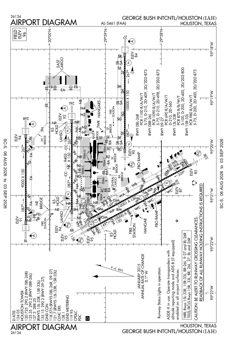
Range from KIAH
Runways
Longest 12,001 ft
Tap a runway to see its details.
Waiting for current wind…
- Dimensions
- 12001 x 150 ft. / 3658 x 46 m
- Surface
- concrete/grooved, in good condition
- Edge lights
- high intensity
- Weight bearing
- PCN PCR/870 /R/B/W/T Single wheel
Runway 15L
- Heading
- 149 magnetic, 152 true
- VGSI / PAPI
- 4-light PAPI on right (3.00 degrees glide path)
- Instrument approach
- ILS
- Approach lights
- MALSR: 1,400 foot medium intensity approach lighting system with runway alignment indicator lights
- Declared distances
- TORA:12001 TODA:12001 ASDA:12001 LDA:12001
- Markings
- nonprecision, in good condition
- Touchdown point
- yes, no lights
- Traffic pattern
- left
- Threshold elevation
- 94.6 ft.
Runway 33R
- Heading
- 329 magnetic, 332 true
- VGSI / PAPI
- RVR equipment
- Approach lights
- Centerline lights
- Declared distances
- TORA:12001 TODA:12001 ASDA:12001 LDA:12001
- Markings
- precision, in good condition
- Touchdown point
- yes, no lights
- Traffic pattern
- left
- Threshold elevation
- 84.9 ft.
- Dimensions
- 10000 x 150 ft. / 3048 x 46 m
- Surface
- concrete/grooved, in good condition
- Edge lights
- high intensity
- Weight bearing
- PCN PCR/690 /R/A/W/T Double wheel
Runway 9
- Heading
- 087 magnetic, 090 true
- VGSI / PAPI
- 4-light PAPI on right (3.00 degrees glide path)
- Instrument approach
- ILS/DME
- Approach lights
- MALSR: 1,400 foot medium intensity approach lighting system with runway alignment indicator lights
- Declared distances
- TORA:10000 TODA:10000 ASDA:10000 LDA:10000
- Markings
- precision, in good condition
- Touchdown point
- yes, no lights
- Traffic pattern
- left
- Threshold elevation
- 89.9 ft.
Runway 27
- Heading
- 267 magnetic, 270 true
- VGSI / PAPI
- 4-light PAPI on left (3.00 degrees glide path)
- Instrument approach
- ILS/DME
- Approach lights
- ALSF2: standard 2,400 foot high intensity approach lighting system with centerline sequenced flashers (category II or III)
- Declared distances
- TORA:10000 TODA:10000 ASDA:10000 LDA:10000
- Markings
- precision, in good condition
- Touchdown point
- yes, lighted
- Traffic pattern
- left
- Threshold elevation
- 84.3 ft.
- Dimensions
- 10000 x 150 ft. / 3048 x 46 m
- Surface
- concrete/grooved, in good condition
- Edge lights
- high intensity
- Weight bearing
- PCN PCR/980 /R/A/W/T Single wheel
Runway 15R
- Heading
- 149 magnetic, 152 true
- VGSI / PAPI
- 4-light PAPI on left (3.00 degrees glide path)
- Instrument approach
- LOC/GS
- Approach lights
- MALSR: 1,400 foot medium intensity approach lighting system with runway alignment indicator lights
- Declared distances
- TORA:10000 TODA:10000 ASDA:10000 LDA:10000
- Markings
- precision, in good condition
- Touchdown point
- yes, lighted
- Traffic pattern
- left
- Threshold elevation
- 94.8 ft.
Runway 33L
- Heading
- 329 magnetic, 332 true
- VGSI / PAPI
- 4-light PAPI on right (3.00 degrees glide path)
- Approach lights
- Centerline lights
- Declared distances
- TORA:10000 TODA:10000 ASDA:10000 LDA:10000
- Markings
- nonprecision, in good condition
- Touchdown point
- yes, lighted
- Traffic pattern
- left
- Threshold elevation
- 86.5 ft.
- Dimensions
- 9402 x 150 ft. / 2866 x 46 m
- Surface
- concrete/grooved, in good condition
- Edge lights
- high intensity
- Weight bearing
- PCN PCR/1090/R/A/W/T Single wheel
Runway 8R
- Heading
- 087 magnetic, 090 true
- VGSI / PAPI
- 4-light PAPI on left (3.00 degrees glide path)
- Instrument approach
- ILS/DME
- Approach lights
- MALSR: 1,400 foot medium intensity approach lighting system with runway alignment indicator lights
- Declared distances
- TORA:9402 TODA:9402 ASDA:9402 LDA:9402
- Markings
- precision, in good condition
- Touchdown point
- yes, lighted
- Traffic pattern
- left
- Threshold elevation
- 94.3 ft.
Runway 26L
- Heading
- 267 magnetic, 270 true
- VGSI / PAPI
- 4-light PAPI on right (3.00 degrees glide path)
- Instrument approach
- ILS/DME
- Approach lights
- ALSF2: standard 2,400 foot high intensity approach lighting system with centerline sequenced flashers (category II or III)
- Declared distances
- TORA:9402 TODA:9402 ASDA:9402 LDA:9402
- Markings
- precision, in good condition
- Touchdown point
- yes, lighted
- Traffic pattern
- left
- Threshold elevation
- 92.3 ft.
- Dimensions
- 9000 x 150 ft. / 2743 x 46 m
- Surface
- concrete/grooved, in excellent condition
- Edge lights
- high intensity
- Weight bearing
- PCN PCR/1100/R/A/W/T Single wheel
Runway 8L
- Heading
- 087 magnetic, 090 true
- Instrument approach
- ILS/DME
- Approach lights
- ALSF2: standard 2,400 foot high intensity approach lighting system with centerline sequenced flashers (category II or III)
- Declared distances
- TORA:9000 TODA:9000 ASDA:9000 LDA:9000
- Markings
- precision, in good condition
- Touchdown point
- yes, lighted
- Traffic pattern
- left
- Threshold elevation
- 90.6 ft.
Runway 26R
- Heading
- 267 magnetic, 270 true
- Instrument approach
- ILS/DME
- Approach lights
- ALSF2: standard 2,400 foot high intensity approach lighting system with centerline sequenced flashers (category II or III)
- Declared distances
- TORA:9000 TODA:9000 ASDA:9000 LDA:9000
- Markings
- precision, in good condition
- Touchdown point
- yes, lighted
- Traffic pattern
- left
- Threshold elevation
- 94.2 ft.
Terminal procedures FAA d-TPP · cycle 2608 · through 0901Z 09/03/26
Departures — DP / ODP 32
- ALEXANDRIA THREE ↗
- ALEXANDRIA THREE, CONT.1 ↗
- BLTWY SEVEN (RNAV) ↗
- BNDTO SIX (RNAV) ↗
- BNDTO SIX (RNAV), CONT.1 ↗
- CRIED ONE ↗
- EL DORADO ONE ↗
- FLYZA FIVE (RNAV) ↗
- FLYZA FIVE (RNAV), CONT.1 ↗
- GIFFA ONE ↗
- GUMBY THREE (RNAV) ↗
- GUMBY THREE (RNAV), CONT.1 ↗
- HOODO SEVEN (RNAV) ↗
- HOODO SEVEN (RNAV), CONT.1 ↗
- INDIE EIGHT (RNAV) ↗
- JUNCTION ONE ↗
- LAKE CHARLES FIVE ↗
- LEONA FOUR ↗
- LEONA FOUR, CONT.1 ↗
- LUFKIN FOUR ↗
- LUFKIN FOUR, CONT.1 ↗
- LURIC EIGHT (RNAV) ↗
- MMUGS FOUR (RNAV) ↗
- MMUGS FOUR (RNAV), CONT.1 ↗
- PITZZ FIVE (RNAV) ↗
- PITZZ FIVE (RNAV), CONT.1 ↗
- RITAA SEVEN (RNAV) ↗
- RITAA SEVEN (RNAV), CONT.1 ↗
- STRYA EIGHT (RNAV) ↗
- STYCK EIGHT (RNAV) ↗
- WYLSN EIGHT (RNAV) ↗
- TAKEOFF MINIMUMS ↗
Approaches — IAP 38
- ILS OR LOC RWY 08L ↗
- ILS OR LOC RWY 08R ↗
- ILS OR LOC RWY 09 ↗
- ILS OR LOC RWY 15R ↗
- ILS OR LOC RWY 26L ↗
- ILS OR LOC RWY 26R ↗
- ILS OR LOC RWY 27 ↗
- ILS OR LOC RWY 33R ↗
- ILS RWY 08L (SA CAT I) ↗
- ILS RWY 26L (SA CAT I) ↗
- ILS RWY 26R (SA CAT I) ↗
- ILS RWY 27 (SA CAT I) ↗
- ILS RWY 08R (SA CAT I - II) ↗
- ILS RWY 09 (SA CAT I - II) ↗
- ILS RWY 08L (CAT II - III) ↗
- ILS RWY 26L (CAT II - III) ↗
- ILS RWY 26R (CAT II - III) ↗
- ILS RWY 27 (CAT II - III) ↗
- GLS RWY 08L ↗
- GLS RWY 08R ↗
- GLS RWY 09 ↗
- GLS RWY 26L ↗
- GLS RWY 26R ↗
- GLS RWY 27 ↗
- RNAV (RNP) Y RWY 08L ↗
- RNAV (RNP) Y RWY 08R ↗
- RNAV (RNP) Y RWY 09 ↗
- RNAV (RNP) Y RWY 26L ↗
- RNAV (RNP) Y RWY 26R ↗
- RNAV (RNP) Y RWY 27 ↗
- RNAV (GPS) RWY 15R ↗
- RNAV (GPS) RWY 33R ↗
- RNAV (GPS) Z RWY 08L ↗
- RNAV (GPS) Z RWY 08R ↗
- RNAV (GPS) Z RWY 09 ↗
- RNAV (GPS) Z RWY 26L ↗
- RNAV (GPS) Z RWY 26R ↗
- RNAV (GPS) Z RWY 27 ↗
Arrivals — STAR 30
- BAZBL ONE (RNAV) ↗
- DOOBI THREE (RNAV) ↗
- DRLLR FIVE (RNAV) ↗
- DRLLR FIVE (RNAV), CONT.1 ↗
- DUUUK FOUR ↗
- GESNR TWO (RNAV) ↗
- GESNR TWO (RNAV), CONT.1 ↗
- GILCO FIVE ↗
- GILCO FIVE, CONT.1 ↗
- GUSHR THREE (RNAV) ↗
- HTOWN THREE (RNAV) ↗
- HUDZY FIVE ↗
- HUDZY FIVE, CONT.1 ↗
- LINKK ONE (RNAV) ↗
- LINKK ONE (RNAV), CONT.1 ↗
- MSCOT FOUR (RNAV) ↗
- NNCEE TWO (RNAV) ↗
- NNCEE TWO (RNAV), CONT.1 ↗
- OHIIO FOUR ↗
- RIICE ONE ↗
- RIICE ONE, CONT.1 ↗
- SKNRD FIVE (RNAV) ↗
- SKNRD FIVE (RNAV), CONT.1 ↗
- SOULL ONE (RNAV) ↗
- SOULL ONE (RNAV), CONT.1 ↗
- TEJAS FIVE (RNAV) ↗
- TEJAS FIVE (RNAV), CONT.1 ↗
- TTORO THREE (RNAV) ↗
- ZEEKK THREE (RNAV) ↗
- ZEEKK THREE (RNAV), CONT.1 ↗
Other charts 1
Procedure charts published by the FAA (public domain). Confirm the current cycle before flight.
Communications
- Control Tower
- Yes
Services
- Fuel
-
100LL $9.23 fullJet A $10.62 fullAirNav, updated nightly
- Fuel available
- 100LL JET-A
- Parking
- hangars and tiedowns
- Airframe service
- MAJOR
- Powerplant service
- MAJOR
- Bottled oxygen
- NONE
- Bulk oxygen
- LOW
Ownership
- Manager
- CLIFF PRICE PO BOX 60106 HOUSTON, TX 77205 Phone 281-233-1131
- Manager phone
- 281-233-1131
Airport data aggregated from public FAA/AirNav sources for reference only — always consult official charts and NOTAMs for flight planning.
